
Longdoz topographic map
Interactive map
Click on the map to display elevation.
About this map
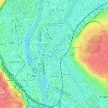
Name: Longdoz topographic map, elevation, terrain.
Location: Longdoz, Liège, Wallonie, 4000, Belgique (50.62204 5.57375 50.63793 5.58871)
Average elevation: 78 m
Minimum elevation: 54 m
Maximum elevation: 135 m
Other topographic maps
Click on a map to view its topography, its elevation and its terrain.
Outremeuse
Outremeuse, Liège, Wallonie, 4000, Belgique
Average elevation: 85 m