
Plage de La Gaillarde topographic map
Interactive map
Click on the map to display elevation.
About this map
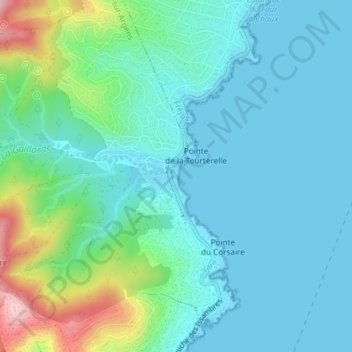
Name: Plage de La Gaillarde topographic map, elevation, terrain.
Average elevation: 44 m
Minimum elevation: 0 m
Maximum elevation: 210 m
Other topographic maps
Click on a map to view its topography, its elevation and its terrain.
La Gaillarde
France > Provence-Alpes-Côte d'Azur > Var > Roquebrune-sur-Argens
La Gaillarde, Roquebrune-sur-Argens, Draguignan, Var, Provence-Alpes-Côte d'Azur, France métropolitaine, France
Average elevation: 101 m
La Bouverie
France > Provence-Alpes-Côte d'Azur > Var > Roquebrune-sur-Argens
La Bouverie, Roquebrune-sur-Argens, Draguignan, Var, Provence-Alpes-Côte d'Azur, France métropolitaine, 83520, France
Average elevation: 84 m