
Make a donation
Ballymaguigan topographic map
Click on the map to display elevation.
Make a donation
About this map
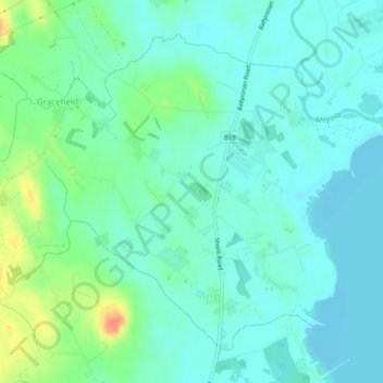
Name: Ballymaguigan topographic map, elevation, terrain.
Average elevation: 21 m
Minimum elevation: 9 m
Maximum elevation: 58 m
Make a donation
Other topographic maps
Click on a map to view its topography, its elevation and its terrain.
Derry/Londonderry
United Kingdom > Northern Ireland > County Londonderry
Derry is characterised by its distinctively hilly topography. The River Foyle forms a deep valley as it flows through the city, making Derry a place of very steep streets and sudden, startling views. The original walled city of Londonderry lies on a hill on the west bank of the River Foyle. In the past, the…
Average elevation: 88 m
Make a donation
Make a donation
Make a donation
Make a donation
Make a donation
Make a donation
Make a donation
Foyle
United Kingdom > Northern Ireland > County Londonderry > Derry/Londonderry
Average elevation: 48 m
Make a donation
Slaughtneil
United Kingdom > Northern Ireland > County Londonderry > Slaughtneil
Average elevation: 136 m
Derry/Londonderry
United Kingdom > Northern Ireland > County Londonderry
Derry is characterised by its distinctively hilly topography. The River Foyle forms a deep valley as it flows through the city, making Derry a place of very steep streets and sudden, startling views. The original walled city of Londonderry lies on a hill on the west bank of the River Foyle. In the past, the…
Average elevation: 88 m
Make a donation
Derry/Londonderry
United Kingdom > Northern Ireland > County Londonderry
Derry is characterised by its distinctively hilly topography. The River Foyle forms a deep valley as it flows through the city, giving it a steep topography. The original walled city of Londonderry lies on a hill on the west bank of the River Foyle. In the past, the river branched and enclosed this hill as an…
Average elevation: 88 m
Make a donation
Foyle
United Kingdom > Northern Ireland > County Londonderry > Derry/Londonderry
Average elevation: 48 m
Make a donation
Bay Road Park
United Kingdom > Northern Ireland > County Londonderry > Derry/Londonderry
Average elevation: 19 m
Make a donation
Derry/Londonderry
United Kingdom > Northern Ireland > County Londonderry
Derry is characterised by its distinctively hilly topography. The River Foyle forms a deep valley as it flows through the city, giving it a steep topography. The original walled city of Londonderry lies on a hill on the west bank of the River Foyle. In the past, the river branched and enclosed this hill as an…
Average elevation: 88 m
Derry/Londonderry
United Kingdom > Northern Ireland > County Londonderry
Derry is characterised by its distinctively hilly topography. The River Foyle forms a deep valley as it flows through the city, making Derry a place of very steep streets and sudden, startling views. The original walled city of Londonderry lies on a hill on the west bank of the River Foyle. In the past, the…
Average elevation: 88 m
Make a donation