
Thank you for supporting this site ❤️
Make a donation
Make a donation
Breznik topographic map
Click on the map to display elevation.
Thank you for supporting this site ❤️
Make a donation
Make a donation
About this map
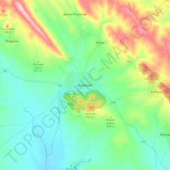
Name: Breznik topographic map, elevation, terrain.
Location: Breznik, Pernik, Bulgaria (42.69977 22.87035 42.77977 22.95035)
Average elevation: 810 m
Minimum elevation: 698 m
Maximum elevation: 1,048 m
Thank you for supporting this site ❤️
Make a donation
Make a donation