
Parcs naturels d’Ischigualasto / Talampaya topographic map
Interactive map
Click on the map to display elevation.
About this map
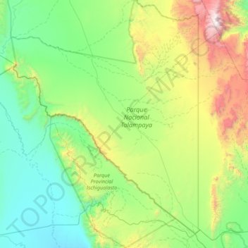
Name: Parcs naturels d’Ischigualasto / Talampaya topographic map, elevation, terrain.
Average elevation: 1,390 m
Minimum elevation: 758 m
Maximum elevation: 3,381 m
Other topographic maps
Click on a map to view its topography, its elevation and its terrain.
Departametno Independencia
Departametno Independencia, La Rioja, F5386, Argentine, Loma Negra
Average elevation: 2,137 m
La Rioja Argentina
Argentine > La Rioja > La Rioja
La Rioja Argentina, La Rioja, Departamento Capital, La Rioja, F5300, Argentine
Average elevation: 498 m