
Thank you for supporting this site ❤️
Make a donation
Make a donation
Sandfell topographic map
Click on the map to display elevation.
Thank you for supporting this site ❤️
Make a donation
Make a donation
About this map
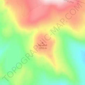
Name: Sandfell topographic map, elevation, terrain.
Location: Sandfell, Rangárþing ytra, Southern Region, Iceland (63.86837 -19.01359 63.86847 -19.01349)
Average elevation: 879 m
Minimum elevation: 646 m
Maximum elevation: 1,167 m
Thank you for supporting this site ❤️
Make a donation
Make a donation
Other topographic maps
Click on a map to view its topography, its elevation and its terrain.