
Falls Creek topographic map
Interactive map
Click on the map to display elevation.
Falls Creek
The Falls Creek Alpine Resort is an alpine ski resort in the Hume region in northeastern Victoria, Australia. It is located in the Alpine National Park in the Victorian Alps, approximately 350 kilometres (220 miles) by road from Melbourne, with the nearest town being Mount Beauty, which is approximately 30 km (20 mi) away. The resort lies between an elevation of 1,210 and 1,830 m (3,970 and 6,004 ft) above sea level, with the highest lifted point at 1,780 m (5,840 ft). Skiing is possible on the nearby peak of Mount McKay at 1,842 m (6,043 ft), accessed by snowcat from the resort.
About this map
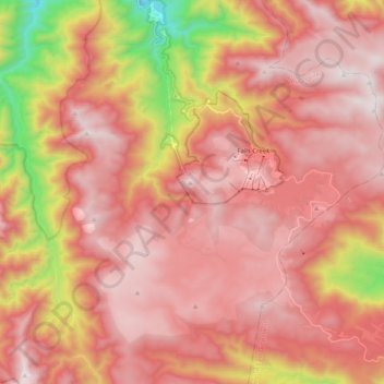
Name: Falls Creek topographic map, elevation, terrain.
Location: Falls Creek, Victoria, 3699, Australia (-36.94013 147.14335 -36.81784 147.34558)
Average elevation: 1,459 m
Minimum elevation: 629 m
Maximum elevation: 1,892 m
Other topographic maps
Click on a map to view its topography, its elevation and its terrain.