
Make a donation
Vashon Island topographic map
Click on the map to display elevation.
Make a donation
Vashon Island
Vashon Island features a diverse topography characterized by rolling hills, lush forests, and scenic waterfronts. The island rises gently from sea level to elevations reaching around 500 feet (approximately 150 meters) at its highest point, providing sweeping views of Puget Sound and the surrounding mountains. The terrain includes a mix of grassy meadows, dense woodlands, and rocky shorelines, creating a varied landscape that supports a rich array of flora and fauna. Additionally, the coastline is dotted with sandy beaches and tide pools, offering a dynamic interaction between land and sea. The combination of these natural features contributes to the island's serene beauty and ecological diversity.
Make a donation
About this map
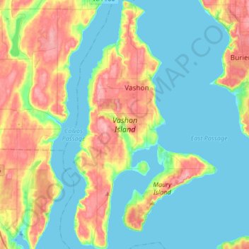
Name: Vashon Island topographic map, elevation, terrain.
Average elevation: 46 m
Minimum elevation: -4 m
Maximum elevation: 154 m
Make a donation