
Thank you for supporting this site ❤️
Make a donation
Make a donation
Zinhain topographic map
Click on the map to display elevation.
Thank you for supporting this site ❤️
Make a donation
Make a donation
Zinhain
Die Ortschaft liegt etwa zwei Kilometer westlich des Stadtzentrums von Bad Marienberg in Hanglage über dem Tal der südlich fließenden Nister auf einer Höhe von durchschnittlich circa 480 m ü. NHN und steigt nach Norden hin bis auf etwa 550 m ü. NHN auf der „Zinhainer Höhe“ an.
Thank you for supporting this site ❤️
Make a donation
Make a donation
About this map
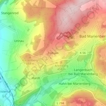
Name: Zinhain topographic map, elevation, terrain.
Average elevation: 438 m
Minimum elevation: 305 m
Maximum elevation: 577 m
Thank you for supporting this site ❤️
Make a donation
Make a donation
Other topographic maps
Click on a map to view its topography, its elevation and its terrain.
Marienbad
Deutschland > Rheinland-Pfalz > Westerwaldkreis > Bad Marienberg (Westerwald) > Zinhain
Average elevation: 450 m