
Thank you for supporting this site ❤️
Make a donation
Make a donation
West End topographic map
Click on the map to display elevation.
Thank you for supporting this site ❤️
Make a donation
Make a donation
About this map
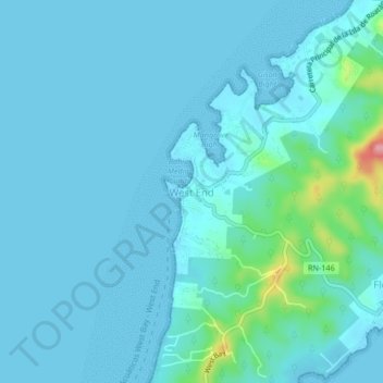
Name: West End topographic map, elevation, terrain.
Location: West End, Roatán, Bay Islands, 34104, Honduras (16.28467 -86.61286 16.32467 -86.57286)
Average elevation: 14 m
Minimum elevation: 0 m
Maximum elevation: 134 m
Thank you for supporting this site ❤️
Make a donation
Make a donation
Other topographic maps
Click on a map to view its topography, its elevation and its terrain.