
Región de Ñuble topographic map
Interactive map
Click on the map to display elevation.
About this map
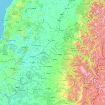
Name: Región de Ñuble topographic map, elevation, terrain.
Location: Región de Ñuble, Chile (-37.19718 -72.88578 -36.00537 -71.00683)
Average elevation: 625 m
Minimum elevation: 0 m
Maximum elevation: 3,160 m
Other topographic maps
Click on a map to view its topography, its elevation and its terrain.
Chillán
Chile > Región de Ñuble > Chillán
Chillán, Provincia de Diguillín, Región de Ñuble, Chile
Average elevation: 165 m