
Make a donation
Rangunia topographic map
Click on the map to display elevation.
Make a donation
About this map
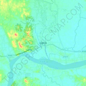
Name: Rangunia topographic map, elevation, terrain.
Location: Rangunia, Chattogram District, Chittagong Division, Bangladesh (22.42934 92.01624 22.50934 92.09624)
Average elevation: 11 m
Minimum elevation: 1 m
Maximum elevation: 56 m
Make a donation
Other topographic maps
Click on a map to view its topography, its elevation and its terrain.
Make a donation
Fatikchhari, Chittagong, Bangladesh
Bangladesh > Chittagong Division > Fatikchhari Upazila > Fatikchhari
Average elevation: 11 m
Make a donation
Make a donation
Make a donation
Make a donation
Sitakunda Upazila
Bangladesh > Chittagong Division
Sitakunda Upazila occupies an area of 483.97 square kilometres (186.86 sq mi), which includes 61.61 square kilometres (23.79 sq mi) of forest. It is bordered by Mirsharai to the north, Pahartali to the south, Fatickchhari, Hathazari and Panchlaish to the east, and the Sandwip Channel in the Bay of Bengal to…
Average elevation: 15 m
Make a donation