
Mestia Municipality topographic map
Click on the map to display elevation.
About this map
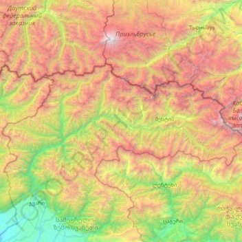
Name: Mestia Municipality topographic map, elevation, terrain.
Location: Mestia Municipality, Samegrelo-Upper Svaneti, Georgia (42.81024 41.86646 43.25698 43.14623)
Average elevation: 2,172 m
Minimum elevation: 118 m
Maximum elevation: 5,597 m
Other topographic maps
Click on a map to view its topography, its elevation and its terrain.
Jvari
Georgia > Samegrelo-Upper Svaneti > Tsalenjikha Municipality
Jvari (Georgian: ჯვარი) is a town in the northwestern Georgian province of Samegrelo-Zemo Svaneti. The town is situated at an altitude of 280 metres near the Magana River where it flows into the Enguri River; The town is divided in two with "Jvari" lying on the Zugdidi-Mestia highway, and Jvarzeni…
Average elevation: 450 m
Ushguli
Georgia > Samegrelo-Upper Svaneti > Mestia Municipality
Ushguli is located at an altitude of 2,100 metres (6,900 ft) near the foot of Shkhara, one of the highest summits of the Greater Caucasus mountains. About 70 families (about 200 people) live in the area, enough to support a small school. The area is snow-covered for 6 months of the year, and often the road to…
Average elevation: 2,409 m
Mestia
Georgia > Samegrelo-Upper Svaneti > Mestia Municipality
Mestia (Georgian: მესტია IPA: [mestʼia]) is a highland townlet (daba) in northwest Georgia, at an elevation of 1,500 metres (4,921 feet) in the Caucasus Mountains.
Average elevation: 1,761 m
Senaki
Georgia > Samegrelo-Upper Svaneti > Senaki Municipality
Senaki (Georgian: სენაკი; Mingrelian: სანაკი) is a town in Samegrelo-Zemo Svaneti region, western Georgia. It is located at around 42°16′8″N 42°4′45″E / 42.26889°N 42.07917°E / 42.26889; 42.07917 between the rivers Tekhura/i and Tsivi, at an elevation of 28–38…
Average elevation: 80 m
Mestia
Georgia > Samegrelo-Upper Svaneti > Mestia Municipality
Mestia (Georgian: მესტია IPA: [mestʼia]) is a highland townlet (daba) in northwest Georgia, at an elevation of 1,500 metres (4,921 feet) in the Caucasus Mountains.
Average elevation: 1,761 m
Senaki
Georgia > Samegrelo-Upper Svaneti > Senaki Municipality
Senaki (Georgian: სენაკი, senak'i; Mingrelian: სანაკი, sanak'i) is a city in Samegrelo-Zemo Svaneti region, western Georgia. It is located at around 42°16′8″N 42°4′45″E / 42.26889°N 42.07917°E / 42.26889; 42.07917 between the rivers Tekhura/i and Tsivi, at an…
Average elevation: 80 m
Jvari
Georgia > Samegrelo-Upper Svaneti > Tsalenjikha Municipality
Jvari (Georgian: ჯვარი) is a town in the northwestern Georgian province of Samegrelo-Zemo Svaneti. The town is situated at an altitude of 280 metres near the Magana River where it flows into the Enguri River; The town is divided in two with "Jvari" lying on the Zugdidi-Mestia highway, and Jvarzeni…
Average elevation: 450 m
Nokalakevi (Tsikhegoji)
Georgia > Samegrelo-Upper Svaneti > Senaki Municipality > Gakhomela
Average elevation: 158 m
Zugdidi
Georgia > Samegrelo-Upper Svaneti > Zugdidi
Zugdidi (Georgian: ზუგდიდი; Mingrelian: ზუგდიდი or ზუგიდი) is a city in the western Georgian historical province of Samegrelo (Mingrelia). It is situated in the north-west of that province. The city is located 318 kilometres west of Tbilisi, 30 km from the Black Sea…
Average elevation: 112 m
Very steep, dangerous route
Georgia > Samegrelo-Upper Svaneti > Mestia Municipality
Average elevation: 1,875 m
Gachedili
Georgia > Samegrelo-Upper Svaneti > Martvili Municipality
Gachedili (Georgian: გაჭედილი; Mingrelian: გოჭკადილი) is a village located in the Martvili Municipality of the Samegrelo-Zemo Svaneti region in Georgia. Gachedili is situated on the right bank of the Abasha river. At an altitude of 240 meters, it is 8 kilometers to Martvili…
Average elevation: 354 m
Nokalakevi (Tsikhegoji)
Georgia > Samegrelo-Upper Svaneti > Senaki Municipality > Gakhomela
Average elevation: 158 m
Mestia
Georgia > Samegrelo-Upper Svaneti > Mestia Municipality
Mestia (Georgian: მესტია IPA: [mestʼia]) is a highland townlet (daba) in northwest Georgia, at an elevation of 1,500 metres (4,921 feet) in the Caucasus Mountains.
Average elevation: 1,761 m