
Thank you for supporting this site ❤️
Make a donation
Make a donation
Markazi Province topographic map
Click on the map to display elevation.
Thank you for supporting this site ❤️
Make a donation
Make a donation
About this map
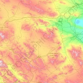
Name: Markazi Province topographic map, elevation, terrain.
Location: Markazi Province, Iran (33.38409 48.94976 35.57061 51.05536)
Average elevation: 1,800 m
Minimum elevation: 798 m
Maximum elevation: 3,587 m
Thank you for supporting this site ❤️
Make a donation
Make a donation
Other topographic maps
Click on a map to view its topography, its elevation and its terrain.
Sarbisheh
Iran > South Khorasan Province > Sarbisheh County > دهستان مؤمن آباد
Average elevation: 1,860 m
Thank you for supporting this site ❤️
Make a donation
Make a donation
Thank you for supporting this site ❤️
Make a donation
Make a donation
شورستان
Iran > South Khorasan Province > Sarbisheh County > دهستان مؤمن آباد
Average elevation: 1,912 m
Baba Jan, East Azerbaijan
Iran > East Azerbaijan Province > Ahar County > دهستان قشلاق
Average elevation: 1,752 m
Thank you for supporting this site ❤️
Make a donation
Make a donation
Pasak
Iran > Sistan and Baluchestan Province > Qasr-e-Ghand County > دهستان هیت > Pasak
Average elevation: 481 m