
Philipsburg topographic map
Interactive map
Click on the map to display elevation.
About this map
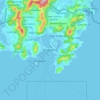
Name: Philipsburg topographic map, elevation, terrain.
Location: Philipsburg, Sint Maarten, Nederland (17.98507 -63.08831 18.06507 -63.00831)
Average elevation: 33 m
Minimum elevation: -4 m
Maximum elevation: 377 m
Other topographic maps
Click on a map to view its topography, its elevation and its terrain.
Valkenburg
Nederland > Limburg > Valkenburg
Valkenburg, Limburg, Nederland, 6301, Nederland
Average elevation: 121 m
Voorthuizen
Voorthuizen, Barneveld, Gelderland, Nederland
Average elevation: 15 m
Den Helder
Nederland > Noord-Holland > Den Helder
Den Helder, Noord-Holland, Nederland
Average elevation: 0 m
Voorschoten
Nederland > Zuid-Holland > Voorschoten
Voorschoten, Zuid-Holland, Nederland
Average elevation: 1 m
Harderwijk
Nederland > Gelderland > Harderwijk
Harderwijk, Gelderland, Nederland
Average elevation: 7 m