
Savannah topographic map
Interactive map
Click on the map to display elevation.
About this map
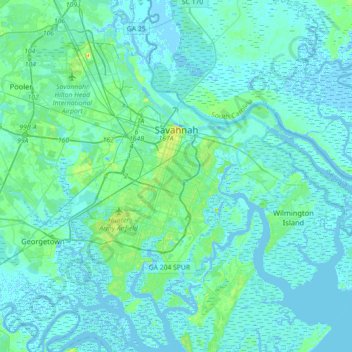
Name: Savannah topographic map, elevation, terrain.
Location: Savannah, Chatham County, Georgia, United States (31.88785 -81.37143 32.18966 -81.02952)
Average elevation: 4 m
Minimum elevation: -5 m
Maximum elevation: 33 m
Savannah is prone to flooding, due to abundant rainfall, an elevation at just above sea level, and the shape of the coastline, which poses a greater surge risk during hurricanes. The city currently uses five canals. In addition, several pumping stations have been built to help reduce the effects of flash flooding.