
Make a donation
Dion - Olympos Municipality topographic map
Click on the map to display elevation.
Make a donation
About this map
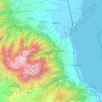
Name: Dion - Olympos Municipality topographic map, elevation, terrain.
Average elevation: 629 m
Minimum elevation: -2 m
Maximum elevation: 2,889 m
Make a donation
Other topographic maps
Click on a map to view its topography, its elevation and its terrain.
Ράχη
Greece > Macedonia and Thrace > Pieria Regional Unit > Katerini Municipality
Average elevation: 202 m
Make a donation
Elatochori
Greece > Macedonia and Thrace > Pieria Regional Unit
Elatochori is known for its ski center, which is located at an altitude of 1,400 to 1,800 meters (4,600 to 5,900 feet) on the southeastern slopes of the Pierian Mountains. At the base of the ski resort and at the location "Papá Choráfi", there is a dining room and a chalet with a total area of 450 sq.m.…
Average elevation: 722 m
Περίσταση
Greece > Macedonia and Thrace > Pieria Regional Unit > Katerini Municipality
The village is located about 3 kilometres (1.8 miles) east of the city of Katerini, in the Pierian Plain. It has an altitude of 23 meters (75 feet) above sea level.
Average elevation: 23 m