
Hargimont topographic map
Interactive map
Click on the map to display elevation.
About this map
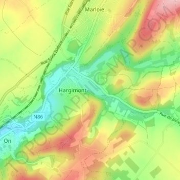
Name: Hargimont topographic map, elevation, terrain.
Location: Hargimont, Marche-en-Famenne, Luxemburg, Wallonië, 6900, België (50.16603 5.27767 50.19924 5.33964)
Average elevation: 268 m
Minimum elevation: 194 m
Maximum elevation: 352 m
Other topographic maps
Click on a map to view its topography, its elevation and its terrain.
Aye
België > Luxemburg > Marche-en-Famenne > Marche-en-Famenne
Aye, Marche-en-Famenne, Luxemburg, Wallonië, 6900, België
Average elevation: 245 m
Roy
België > Luxemburg > Marche-en-Famenne > Marche-en-Famenne
Roy, Marche-en-Famenne, Luxemburg, Wallonië, 6900, België
Average elevation: 342 m
Marche-en-Famenne
België > Luxemburg > Marche-en-Famenne > Marche-en-Famenne
Marche-en-Famenne, Luxemburg, Wallonië, 6900, België
Average elevation: 252 m
Humain
België > Luxemburg > Marche-en-Famenne > Marche-en-Famenne
Humain, Marche-en-Famenne, Luxemburg, Wallonië, 6900, België
Average elevation: 246 m
Waha
België > Luxemburg > Marche-en-Famenne > Marche-en-Famenne > Waha
Waha, Marche-en-Famenne, Luxemburg, Wallonië, 6900, België
Average elevation: 265 m