
Nord-Pas-de-Calais topographic map
Interactive map
Click on the map to display elevation.
About this map
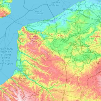
Name: Nord-Pas-de-Calais topographic map, elevation, terrain.
Location: Nord-Pas-de-Calais, Metropolitan France, France (49.96892 1.55562 51.08899 4.23119)
Average elevation: 55 m
Minimum elevation: -4 m
Maximum elevation: 246 m
Other topographic maps
Click on a map to view its topography, its elevation and its terrain.
Val Thorens
France > Auvergne-Rhône-Alpes > Savoy
Val Thorens ([val tɔʁɑ̃]) is a ski town in the Tarentaise Valley in the French Alps at an altitude of 2,300 m (7,500 ft). It is located in the commune of Saint-Martin-de-Belleville in the Savoie department. The resort forms part of the Les Trois Vallées ski area which, with over 600 km of slopes, is one…
Average elevation: 2,516 m
Laudibertie
France > Nouvelle-Aquitaine > Dordogne > Saint-Privat-en-Périgord > Festalemps
Average elevation: 93 m
Lavillemichel
France > Nouvelle-Aquitaine > Haute-Vienne > Bessines-sur-Gartempe
Average elevation: 349 m
Beauregard
France > Bourgogne – Franche-Comté > Nièvre > Saint-Amand-en-Puisaye
Average elevation: 220 m
La Fageole
France > Nouvelle-Aquitaine > Dordogne > Saint-Félix-de-Reillac-et-Mortemart
Average elevation: 213 m
Les Gardes
France > Auvergne-Rhône-Alpes > Cantal > Saint-Jacques-des-Blats
Average elevation: 1,266 m
Le Balestier
France > New Aquitaine > Coux et Bigaroque-Mouzens > Le Balestier
Average elevation: 171 m
La Madone de Fenestre
France > Provence-Alpes-Côte d'Azur > Saint-Martin-Vésubie > La Madone de Fenestre
Average elevation: 2,202 m
Paris
Paris in its early history had only the rivers Seine and Bièvre for water. From 1809, the Canal de l'Ourcq provided Paris with water from less-polluted rivers to the north-east of the capital. From 1857, the civil engineer Eugène Belgrand, under Napoleon III, oversaw the construction of a series of new…
Average elevation: 75 m