
Make a donation
Chelyabinsk Oblast topographic map
Click on the map to display elevation.
Make a donation
Chelyabinsk Oblast
The West Siberian Plain is bounded on the west horizontal (elevation 190 m above sea level), which passes through the village of Bagaryak, Kunashak and continues through Chelyabinsk to the south. The lowlands are located in the northeast, and the elevation drops to 130 m in the eastern border region.
Make a donation
About this map
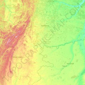
Name: Chelyabinsk Oblast topographic map, elevation, terrain.
Location: Chelyabinsk Oblast, Ural Federal District, Russia (51.99088 57.13129 56.36572 63.35201)
Average elevation: 301 m
Minimum elevation: 63 m
Maximum elevation: 1,525 m
Make a donation
Other topographic maps
Click on a map to view its topography, its elevation and its terrain.
Make a donation
Make a donation
Make a donation
Make a donation
Заозерье
Russia > Moscow Oblast > городской округ Павловский Посад > Заозерье
Average elevation: 138 m
Make a donation
Make a donation
Заводопетровское
Russia > Tyumen Oblast > Yalutorovsky District > Заводопетровское
Average elevation: 75 m
Make a donation
Make a donation