
Thank you for supporting this site ❤️
Make a donation
Make a donation
Liverpool topographic map
Click on the map to display elevation.
Thank you for supporting this site ❤️
Make a donation
Make a donation
About this map
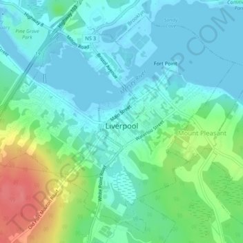
Name: Liverpool topographic map, elevation, terrain.
Average elevation: 19 m
Minimum elevation: -2 m
Maximum elevation: 72 m
Thank you for supporting this site ❤️
Make a donation
Make a donation
Other topographic maps
Click on a map to view its topography, its elevation and its terrain.
Port Mouton Island
Canada > Nova Scotia > Queens County > South West Port Mouton
Average elevation: 27 m