
Thank you for supporting this site ❤️
Make a donation
Make a donation
Riel-les-Eaux topographic map
Click on the map to display elevation.
Thank you for supporting this site ❤️
Make a donation
Make a donation
About this map
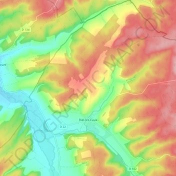
Name: Riel-les-Eaux topographic map, elevation, terrain.
Average elevation: 274 m
Minimum elevation: 200 m
Maximum elevation: 350 m
Thank you for supporting this site ❤️
Make a donation
Make a donation
Other topographic maps
Click on a map to view its topography, its elevation and its terrain.
Le Petit Cirey
Франция > Бургундия — Франш-Конте > Кот-д'Ор > Nolay > Le Petit Cirey
Average elevation: 416 m