
Thank you for supporting this site ❤️
Make a donation
Make a donation
Oberkotten topographic map
Click on the map to display elevation.
Thank you for supporting this site ❤️
Make a donation
Make a donation
About this map
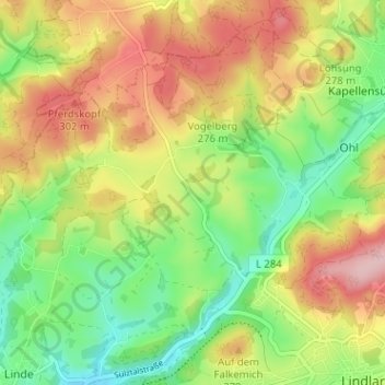
Name: Oberkotten topographic map, elevation, terrain.
Average elevation: 241 m
Minimum elevation: 158 m
Maximum elevation: 341 m
Thank you for supporting this site ❤️
Make a donation
Make a donation
Other topographic maps
Click on a map to view its topography, its elevation and its terrain.
51789
Deutschland > Nordrhein-Westfalen > Oberbergischer Kreis > Lindlar > Süttenbach
Average elevation: 237 m