
Thank you for supporting this site ❤️
Make a donation
Make a donation
Lagares topographic map
Click on the map to display elevation.
Thank you for supporting this site ❤️
Make a donation
Make a donation
About this map
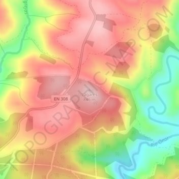
Name: Lagares topographic map, elevation, terrain.
Location: Lagares, Bragance, Portugal (41.88727 -6.64882 41.88737 -6.64872)
Average elevation: 745 m
Minimum elevation: 607 m
Maximum elevation: 838 m
Thank you for supporting this site ❤️
Make a donation
Make a donation
Other topographic maps
Click on a map to view its topography, its elevation and its terrain.