
Thank you for supporting this site ❤️
Make a donation
Make a donation
Mela topographic map
Click on the map to display elevation.
Thank you for supporting this site ❤️
Make a donation
Make a donation
About this map
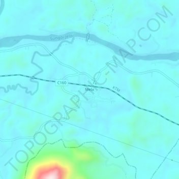
Name: Mela topographic map, elevation, terrain.
Location: Mela, Lipis, Pahang, 27010, Malaysia (4.05457 102.25163 4.09457 102.29163)
Average elevation: 81 m
Minimum elevation: 36 m
Maximum elevation: 476 m
Thank you for supporting this site ❤️
Make a donation
Make a donation
Other topographic maps
Click on a map to view its topography, its elevation and its terrain.
Thank you for supporting this site ❤️
Make a donation
Make a donation