
Thank you for supporting this site ❤️
Make a donation
Make a donation
Gulberga topographic map
Click on the map to display elevation.
Thank you for supporting this site ❤️
Make a donation
Make a donation
About this map
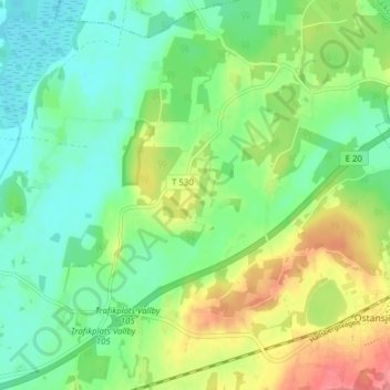
Name: Gulberga topographic map, elevation, terrain.
Location: Gulberga, Hallsbergs kommun, Örebro County, 694 72, Sweden (59.03701 14.92596 59.07701 14.96596)
Average elevation: 77 m
Minimum elevation: 51 m
Maximum elevation: 124 m
Thank you for supporting this site ❤️
Make a donation
Make a donation