
Make a donation
Mound House topographic map
Click on the map to display elevation.
Make a donation
Mound House
Mound House is a small unincorporated community in Lyon County, Nevada on U.S. Route 50 that is situated between Nevada's capital, Carson City, and Dayton. Its elevation is 4,974 feet (1,516 m). It is in Lyon County, one of eight Nevada counties that allow for legalized prostitution, and is home to four brothels.
Make a donation
About this map
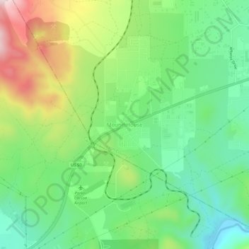
Name: Mound House topographic map, elevation, terrain.
Location: Mound House, Lyon County, Nevada, United States (39.19224 -119.69581 39.23224 -119.65581)
Average elevation: 1,521 m
Minimum elevation: 1,359 m
Maximum elevation: 1,810 m
Make a donation
Other topographic maps
Click on a map to view its topography, its elevation and its terrain.
Yerington
United States > Nevada > Lyon County
During the summer, temperatures are generally hot to very hot in the afternoon, but the high altitude and low humidity means temperature drop to a comfortable level at night. On average, 8.0 afternoons each summer will exceed 100 °F or 37.8 °C and 73.2 afternoons reach 90 °F (32.2 °C). It is rare, though,…
Average elevation: 1,358 m