
Troche topographic map
Interactive map
Click on the map to display elevation.
About this map
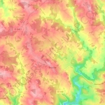
Name: Troche topographic map, elevation, terrain.
Average elevation: 373 m
Minimum elevation: 280 m
Maximum elevation: 424 m
Other topographic maps
Click on a map to view its topography, its elevation and its terrain.
Lintillac
France > Nouvelle-Aquitaine > Corrèze > Ussac
Lintillac, Ussac, Brive-la-Gaillarde, Corrèze, Nouvelle-Aquitaine, France métropolitaine, 19270, France
Average elevation: 121 m
Aubazines
France > Nouvelle-Aquitaine > Corrèze
Aubazines, Brive-la-Gaillarde, Corrèze, Nouvelle-Aquitaine, France métropolitaine, 19190, France
Average elevation: 355 m
Lafage-sur-Sombre
France > Nouvelle-Aquitaine > Corrèze
Lafage-sur-Sombre, Ussel, Corrèze, Nouvelle-Aquitaine, France métropolitaine, 19320, France
Average elevation: 592 m
Lapleau
France > Nouvelle-Aquitaine > Corrèze
Lapleau, Ussel, Corrèze, Nouvelle-Aquitaine, France métropolitaine, 19550, France
Average elevation: 501 m
Albignac
France > Nouvelle-Aquitaine > Corrèze > Albignac
Albignac, Brive-la-Gaillarde, Corrèze, Nouvelle-Aquitaine, France métropolitaine, 19190, France
Average elevation: 322 m
Uzerche
France > Nouvelle-Aquitaine > Corrèze > Uzerche
Uzerche, Tulle, Corrèze, Nouvelle-Aquitaine, France métropolitaine, 19140, France
Average elevation: 371 m
Brive-la-Gaillarde
France > Nouvelle-Aquitaine > Corrèze
Brive-la-Gaillarde, Corrèze, Nouvelle-Aquitaine, France métropolitaine, 19100, France
Average elevation: 178 m