
Dättwil topographic map
Interactive map
Click on the map to display elevation.
About this map
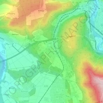
Name: Dättwil topographic map, elevation, terrain.
Location: Dättwil, Baden, Bezirk Baden, Aargau, 5405, Schweiz (47.43373 8.26497 47.47373 8.30497)
Average elevation: 456 m
Minimum elevation: 344 m
Maximum elevation: 647 m
Other topographic maps
Click on a map to view its topography, its elevation and its terrain.
Baldegg
Schweiz > Aargau > Bezirk Baden > Baden
Baldegg, Baden, Bezirk Baden, Aargau, 5404, Schweiz
Average elevation: 453 m