
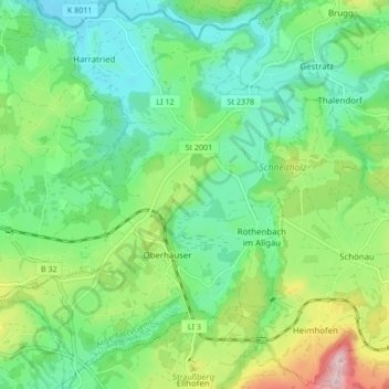
Röthenbach (Allgäu) topographic map
Interactive map
Click on the map to display elevation.
About this map
Name: Röthenbach (Allgäu) topographic map, elevation, terrain.
Average elevation: 683 m
Minimum elevation: 590 m
Maximum elevation: 900 m
Other topographic maps
Click on a map to view its topography, its elevation and its terrain.
Weißensberg
Deutschland > Bayern > Landkreis Lindau
Weißensberg, Sigmarszell (VGem), Landkreis Lindau, Bayern, Deutschland
Average elevation: 506 m
Lindenberg im Allgäu
Deutschland > Bayern > Landkreis Lindau
Lindenberg im Allgäu, Landkreis Lindau, Bayern, 88161, Deutschland
Average elevation: 738 m
Ebnit
Deutschland > Bayern > Landkreis Lindau > Lindau (Bodensee) > Schönau > Ebnit
Ebnit, Schönau, Lindau (Bodensee), Landkreis Lindau, Bayern, 88131, Deutschland
Average elevation: 444 m
Lindau (Bodensee)
Deutschland > Bayern > Landkreis Lindau
Lindau (Bodensee), Landkreis Lindau, Bayern, 88131, Deutschland
Average elevation: 448 m