
Ciudad del Carmen topographic map
Interactive map
Click on the map to display elevation.
About this map
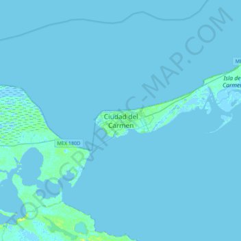
Name: Ciudad del Carmen topographic map, elevation, terrain.
Location: Ciudad del Carmen, Carmen, Campeche, 24100, Mexico (18.49174 -91.97492 18.81174 -91.65492)
Average elevation: 1 m
Minimum elevation: -5 m
Maximum elevation: 13 m
Other topographic maps
Click on a map to view its topography, its elevation and its terrain.
COL. MADERAS
Mexico > Campeche > Carmen > Ciudad del Carmen
COL. MADERAS, Ciudad del Carmen, Carmen, Campeche, 24100, Mexico
Average elevation: 2 m