
Thank you for supporting this site ❤️
Make a donation
Make a donation
Mont Kaaikop topographic map
Click on the map to display elevation.
Thank you for supporting this site ❤️
Make a donation
Make a donation
About this map
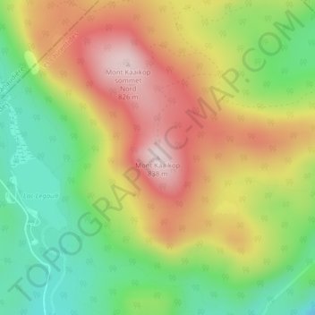
Name: Mont Kaaikop topographic map, elevation, terrain.
Average elevation: 620 m
Minimum elevation: 434 m
Maximum elevation: 822 m
Thank you for supporting this site ❤️
Make a donation
Make a donation
Other topographic maps
Click on a map to view its topography, its elevation and its terrain.
Lac MacShane
Canada > Québec > Les Laurentides > Sainte-Lucie-des-Laurentides
Average elevation: 424 m
Lac Saint-Michel
Canada > Québec > Les Laurentides > Sainte-Lucie-des-Laurentides
Average elevation: 474 m