
Finnentrop topographic map
Interactive map
Click on the map to display elevation.
About this map
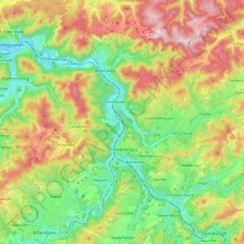
Name: Finnentrop topographic map, elevation, terrain.
Average elevation: 380 m
Minimum elevation: 202 m
Maximum elevation: 649 m
Other topographic maps
Click on a map to view its topography, its elevation and its terrain.
Olpe
Allemagne > Rhénanie-du-Nord-Westphalie > Kreis Olpe
Olpe, Kreis Olpe, Rhénanie-du-Nord-Westphalie, 57462, Allemagne
Average elevation: 400 m