
Ghaziabad topographic map
Interactive map
Click on the map to display elevation.
About this map
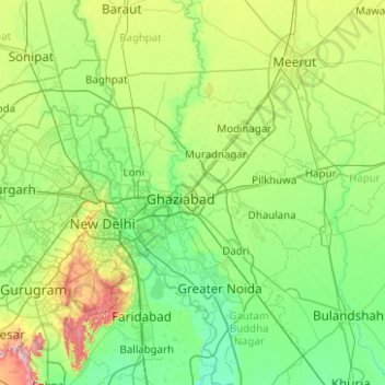
Name: Ghaziabad topographic map, elevation, terrain.
Location: Ghaziabad, Uttar Pradesh, India (28.60913 77.19924 28.92813 77.70791)
Average elevation: 216 m
Minimum elevation: 196 m
Maximum elevation: 252 m
Other topographic maps
Click on a map to view its topography, its elevation and its terrain.
RamLeela Ground, Sanjay Nagar
India > Uttar Pradesh > Ghaziabad > Ghaziabad
RamLeela Ground, Sanjay Nagar, Ghaziabad, Uttar Pradesh, 201001, India
Average elevation: 217 m