
La Estación topographic map
Interactive map
Click on the map to display elevation.
About this map
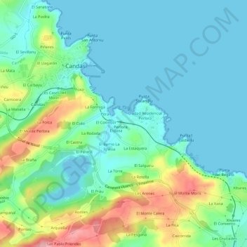
Name: La Estación topographic map, elevation, terrain.
Location: La Estación, Candás, Carreño, Asturias, 33491, España (43.56071 -5.77338 43.60071 -5.73338)
Average elevation: 35 m
Minimum elevation: -13 m
Maximum elevation: 136 m
Other topographic maps
Click on a map to view its topography, its elevation and its terrain.
La Estación
España > Asturias > Carreño > Candás > La Estación
La Estación, Candás, Carreño, Asturias, 33430, España
Average elevation: 44 m