
Thank you for supporting this site ❤️
Make a donation
Make a donation
Murphysboro topographic map
Click on the map to display elevation.
Thank you for supporting this site ❤️
Make a donation
Make a donation
About this map
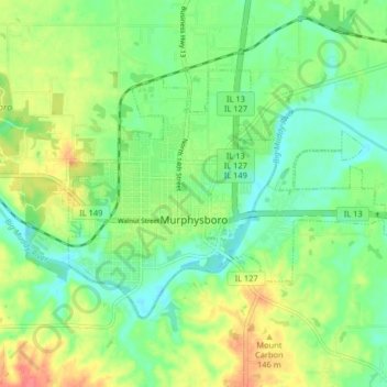
Name: Murphysboro topographic map, elevation, terrain.
Location: Murphysboro, Jackson County, Illinois, 62966, United States (37.74816 -89.36151 37.78931 -89.28020)
Average elevation: 126 m
Minimum elevation: 103 m
Maximum elevation: 162 m
Thank you for supporting this site ❤️
Make a donation
Make a donation
Other topographic maps
Click on a map to view its topography, its elevation and its terrain.