
San Rafael topographic map
Interactive map
Click on the map to display elevation.
About this map
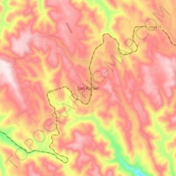
Name: San Rafael topographic map, elevation, terrain.
Location: San Rafael, Urique, Chihuahua, México (27.44689 -107.93107 27.52689 -107.85107)
Average elevation: 2,203 m
Minimum elevation: 1,792 m
Maximum elevation: 2,412 m
Other topographic maps
Click on a map to view its topography, its elevation and its terrain.
Parque de aventura Barrancas del cobre
Parque de aventura Barrancas del cobre, Urique, Chihuahua, México
Average elevation: 2,052 m
Barrancas del Cobre
Barrancas del Cobre, Ruta Panoramica, El Aguaje, Urique, Chihuahua, México
Average elevation: 1,619 m