
Make a donation
San Vicente topographic map
Click on the map to display elevation.
Make a donation
About this map
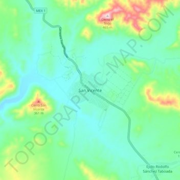
Name: San Vicente topographic map, elevation, terrain.
Average elevation: 157 m
Minimum elevation: 60 m
Maximum elevation: 469 m
Make a donation
Other topographic maps
Click on a map to view its topography, its elevation and its terrain.
Ejido El Porvenir
Mexico > Baja California > Municipio de Ensenada
The valley slopes gently from northeast to southwest with an average elevation of 344 metres (1,129 ft) above sea level. The margins of the plain are composed of alluvial fans and colluvium of reddish soil from the surrounding hillsides. Chaparral grows along the rocky slopes and live oak trees can be found in…
Average elevation: 317 m
Make a donation
Laguna de Santo Tomás
Mexico > Baja California > Municipio de Ensenada > La Bocana
Average elevation: 40 m
Parque Nacional Sierra de San Pedro Mártir
Mexico > Baja California > Municipio de Ensenada
Sierra de San Pedro Mártir National Park was officially created by decree on April 26, 1947, in which 72,909 hectares were set aside and declared protected by the Mexican Federal government. The National Astronomical Observatory is located at an elevation of 2,830 m (9,280 ft). The observatory was built in…
Average elevation: 1,463 m
Isla Guadalupe
Mexico > Baja California > Municipio de Ensenada
Campo Pista is located at the small airport, near the center of the island (29°01′24.04″N 118°16′21.75″W / 29.0233444°N 118.2727083°W / 29.0233444; -118.2727083, elevation:592 m, direction:05/23).[1] Airport Isla Guadalupe (ICAO Code MMGD) has a 1,200-metre-long (3,900 ft) runway. At the…
Average elevation: 113 m