
Thank you for supporting this site ❤️
Make a donation
Make a donation
Les Roubins topographic map
Click on the map to display elevation.
Thank you for supporting this site ❤️
Make a donation
Make a donation
About this map
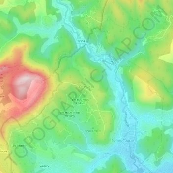
Name: Les Roubins topographic map, elevation, terrain.
Average elevation: 235 m
Minimum elevation: 87 m
Maximum elevation: 523 m
Thank you for supporting this site ❤️
Make a donation
Make a donation
Other topographic maps
Click on a map to view its topography, its elevation and its terrain.
83210
France > Provence-Alpes-Côte d'Azur > Var > Solliès-Toucas > Les Hauts Pieds Redons
Average elevation: 303 m