
Make a donation
Morter topographic map
Click on the map to display elevation.
Make a donation
About this map
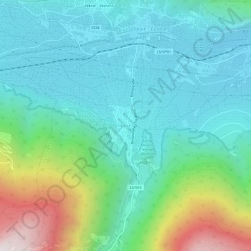
Name: Morter topographic map, elevation, terrain.
Average elevation: 941 m
Minimum elevation: 629 m
Maximum elevation: 1,942 m
Make a donation
Other topographic maps
Click on a map to view its topography, its elevation and its terrain.
Urtijëi - St. Ulrich in Gröden - Ortisei
Italy > Trentino – Alto Adige/Südtirol > South Tyrol
To the north and northeast, above the valley floor of Urtijëi, lie the western foothills of the Geisler Group, part of the Dolomites. In the northeast, the municipality reaches its highest point at Seceda (2519 m, Secëda). South of Seceda, the Pitschberg (2363 m, Pic) projects into the valley. To the west of…
Average elevation: 1,689 m
Gherdëina - Grödnertal - Val Gardena
Italy > Trentino – Alto Adige/Südtirol > South Tyrol > Urtijëi - St. Ulrich in Gröden - Ortisei
Average elevation: 1,607 m
Bolzano - Bozen
Italy > Trentino – Alto Adige/Südtirol > South Tyrol
The area of the city of Bolzano is 52.3 km2 (20 sq. mi.), of which 28 km2 (10 sq. mi.) is used as a settlement area. The city is located in the basin where the Sarntal, Eisacktal, and the Adige Valley with their rivers, Talfer, Eisack, and Adige, meet. In the Middle Ages, the two main Alpine crossings, the Via…
Average elevation: 716 m
Make a donation
Kaltern an der Weinstraße - Caldaro sulla Strada del Vino
Italy > Trentino – Alto Adige/Südtirol > South Tyrol
Average elevation: 798 m
Ritten - Renon
Italy > Trentino – Alto Adige/Südtirol > South Tyrol
The 111-square-kilometre (43 sq mi) community is named after the high plateau, elevation 1,100 to 1,400 metres (3,600 to 4,600 ft), the Ritten or the Renon, on which most of the villages are located. The plateau forms the southeast tip of the Sarntal Alps mountain range and is located between, and on average…
Average elevation: 1,123 m
San Martin de Tor - San Martino in Badia - St. Martin in Thurn
Italy > Trentino – Alto Adige/Südtirol > South Tyrol
Average elevation: 1,837 m
Salorno sulla Strada del Vino - Salurn an der Weinstraße
Italy > Trentino – Alto Adige/Südtirol > South Tyrol
Average elevation: 774 m
Make a donation
Bruneck - Brunico
Italy > Trentino – Alto Adige/Südtirol > South Tyrol
Bruneck rises up in the middle of a wide valley (perhaps an ancient lake basin) and lies at the confluence of the Ahr with the Rienz, which itself flows into the Eisack river. Here the northern Tauferer Ahrntal side valley and the southern Val Badia of the Gran Ega creek join the broad Pustertal. Bruneck wide…
Average elevation: 1,251 m
Ahrntal - Valle Aurina
Italy > Trentino – Alto Adige/Südtirol > South Tyrol
Weißenbach is composed of picturesque Alpine farmhouses, grouped around the foaming white glacial stream from which its name is derived. With a population of around 550, it has an elevation of 1,350 metres (4,430 ft) above sea level.
Average elevation: 2,079 m
Make a donation
Corvara in Badia - Corvara
Italy > Trentino – Alto Adige/Südtirol > South Tyrol
Average elevation: 2,037 m
Langtauferer Tal - Vallelunga
Italy > Trentino – Alto Adige/Südtirol > South Tyrol > Graun - Curon Venosta
Average elevation: 2,513 m
La Val - Wengen - La Valle
Italy > Trentino – Alto Adige/Südtirol > South Tyrol
Average elevation: 1,669 m
Make a donation
Urtijëi - St. Ulrich in Gröden - Ortisei
Italy > Trentino – Alto Adige/Südtirol > South Tyrol
To the north and northeast, above the valley floor of Urtijëi, lie the western foothills of the Geisler Group, part of the Dolomites. In the northeast, the municipality reaches its highest point at Seceda (2519 m, Secëda). South of Seceda, the Pitschberg (2363 m, Pic) projects into the valley. To the west of…
Average elevation: 1,689 m
Bolzano - Bozen
Italy > Trentino – Alto Adige/Südtirol > South Tyrol
The area of the city of Bolzano is 52.3 km2 (20.2 sq mi), of which 28 km2 (11 sq mi) is used as a settlement area. The city is located in the basin where the Sarntal, Eisacktal, and the Adige Valley with their rivers, Talfer, Eisack, and Adige, meet. In the Middle Ages, the two main Alpine crossings, the Via…
Average elevation: 716 m
Neumarkt - Egna
Italy > Trentino – Alto Adige/Südtirol > South Tyrol
The town is situated on the plain, elevation 214 metres (702 ft), on the left side of the Adige river.
Average elevation: 760 m
Make a donation
Martell - Martello
Italy > Trentino – Alto Adige/Südtirol > South Tyrol
Martell (German pronunciation: [marˈtɛl]; Italian: Martello [marˈtɛllo]) is a valley and comune (municipality) in South Tyrol in northern Italy. It is located in the Martell Valley of the 28.5-kilometre (17.7 mi) long river Plima, about 45 kilometres (28 mi) west of Bolzano. The commune reaches from an…
Average elevation: 2,512 m
Grünsee - Lago Verde
Italy > Trentino – Alto Adige/Südtirol > South Tyrol > Ulten - Ultimo
Average elevation: 2,683 m
La Val - Wengen - La Valle
Italy > Trentino – Alto Adige/Südtirol > South Tyrol
Average elevation: 1,669 m
Make a donation
La Val - Wengen - La Valle
Italy > Trentino – Alto Adige/Südtirol > South Tyrol
Average elevation: 1,669 m
Ritten - Renon
Italy > Trentino – Alto Adige/Südtirol > South Tyrol
The 111-square-kilometre (43 mi2) community is named after the high plateau, elevation 1,100 to 1,400 metres (3,600 to 4,600 ft), the Ritten or the Renon, on which most of the villages are located. The plateau forms the southeast tip of the Sarntal Alps mountain range and is located between, and on average 800…
Average elevation: 1,123 m
Make a donation
Make a donation
Ahrntal - Valle Aurina
Italy > Trentino – Alto Adige/Südtirol > South Tyrol
Weißenbach is composed of picturesque Alpine farmhouses, grouped around the foaming white glacial stream from which its name is derived. With a population of around 550, it has an elevation of 1,350 metres (4,430 ft) above sea level.
Average elevation: 2,079 m
Tierseralpl - Alpe di Tires
Italy > Trentino – Alto Adige/Südtirol > South Tyrol > Tiers - Tires
Average elevation: 2,285 m
Salorno sulla Strada del Vino - Salurn an der Weinstraße
Italy > Trentino – Alto Adige/Südtirol > South Tyrol
Average elevation: 774 m
Make a donation
Corvara in Badia - Corvara
Italy > Trentino – Alto Adige/Südtirol > South Tyrol
Average elevation: 2,037 m
Make a donation
Sarns - Sarnes
Italy > Trentino – Alto Adige/Südtirol > South Tyrol > Brixen - Bressanone
Average elevation: 726 m
Urtijëi - St. Ulrich in Gröden - Ortisei
Italy > Trentino – Alto Adige/Südtirol > South Tyrol
Average elevation: 1,689 m
Meran - Merano
Italy > Trentino – Alto Adige/Südtirol > South Tyrol
The average daily temperatures in summer in Merano lie between 27 and 30 °C, while at night temperatures usually drop to between 12 and 15 °C. The average daily temperatures in winter lie between 6 and 10 °C, while at night temperatures usually drop to between -4 and -2 °C. The wettest month is August with…
Average elevation: 635 m
Make a donation
Bolzano - Bozen
Italy > Trentino – Alto Adige/Südtirol > South Tyrol
The area of the city of Bolzano is 52.3 km2 (20.2 sq mi), of which 28 km2 (11 sq mi) is used as a settlement area. The city is located in the basin where the Sarntal, Eisacktal, and the Adige Valley with their rivers, Talfer, Eisack, and Adige, meet. In the Middle Ages, the two main Alpine crossings, the Via…
Average elevation: 716 m
Make a donation
Meran - Merano
Italy > Trentino – Alto Adige/Südtirol > South Tyrol
The average daily temperatures in summer in Merano lie between 27 and 30 °C, while at night temperatures usually drop to between 12 and 15 °C. The average daily temperatures in winter lie between 6 and 10 °C, while at night temperatures usually drop to between -4 and -2 °C. The wettest month is August with…
Average elevation: 635 m
Ritten - Renon
Italy > Trentino – Alto Adige/Südtirol > South Tyrol
The 111-square-kilometre (43 sq mi) community is named after the high plateau, elevation 1,100 to 1,400 metres (3,600 to 4,600 ft), the Ritten or the Renon, on which most of the villages are located. The plateau forms the southeast tip of the Sarntal Alps mountain range and is located between, and on average…
Average elevation: 1,123 m
Mühlbach - Rio di Pusteria
Italy > Trentino – Alto Adige/Südtirol > South Tyrol
Average elevation: 1,737 m
Make a donation
Jenesien - San Genesio Atesino
Italy > Trentino – Alto Adige/Südtirol > South Tyrol
Average elevation: 1,136 m
Make a donation
La Val - Wengen - La Valle
Italy > Trentino – Alto Adige/Südtirol > South Tyrol
Average elevation: 1,669 m
Rasen-Antholz - Rasun-Anterselva
Italy > Trentino – Alto Adige/Südtirol > South Tyrol
Rasen-Antholz is known for the South Tyrol Arena biathlon track, which opened in 1971. It hosted the Biathlon World Championships in 1975, 1976, 1983, 1995, 2007 and 2020. It is also a regular venue of the Biathlon World Cup season, with the highest altitude of all World Cup meetings at a height of about 1,600…
Average elevation: 1,934 m
Make a donation
Deutschnofen - Nova Ponente
Italy > Trentino – Alto Adige/Südtirol > South Tyrol
Average elevation: 1,245 m
Urtijëi - St. Ulrich in Gröden - Ortisei
Italy > Trentino – Alto Adige/Südtirol > South Tyrol
Average elevation: 1,689 m
Meran - Merano
Italy > Trentino – Alto Adige/Südtirol > South Tyrol
The average daily temperatures in summer in Merano lie between 27 and 30 °C, while at night temperatures usually drop to between 12 and 15 °C. The average daily temperatures in winter lie between 6 and 10 °C, while at night temperatures usually drop to between -4 and -2 °C. The wettest month is August with…
Average elevation: 635 m
Make a donation
Mühlbach - Rio di Pusteria
Italy > Trentino – Alto Adige/Südtirol > South Tyrol
Average elevation: 1,737 m
Bolzano - Bozen
Italy > Trentino – Alto Adige/Südtirol > South Tyrol
The area of the city of Bolzano is 52.3 km2 (20.2 sq mi), of which 28 km2 (11 sq mi) is used as a settlement area. The city is located in the basin where the Sarntal, Eisacktal, and the Adige Valley with their rivers, Talfer, Eisack, and Adige, meet. In the Middle Ages, the two main Alpine crossings, the Via…
Average elevation: 716 m
Make a donation
Karneid - Cornedo all'Isarco
Italy > Trentino – Alto Adige/Südtirol > South Tyrol
Average elevation: 904 m
Kastelruth - Castelrotto
Italy > Trentino – Alto Adige/Südtirol > South Tyrol
Average elevation: 1,561 m
Make a donation
Obermais - Maia Alta
Italy > Trentino – Alto Adige/Südtirol > South Tyrol > Meran - Merano
Average elevation: 483 m
Moos in Passeier - Moso in Passiria
Italy > Trentino – Alto Adige/Südtirol > South Tyrol
Average elevation: 2,082 m
Make a donation
Pragser Wildsee - Lago di Braies
Italy > Trentino – Alto Adige/Südtirol > South Tyrol > Prags - Braies
Average elevation: 1,744 m
Kastelruth - Castelrotto
Italy > Trentino – Alto Adige/Südtirol > South Tyrol
Average elevation: 1,561 m
Sëlva - Wolkenstein - Selva di Val Gardena
Italy > Trentino – Alto Adige/Südtirol > South Tyrol
Sëlva is characterized by a typical Alpine climate. Summers are rather short and relatively wet. The average daily temperatures in summer lie between 18 and 21 °C, while at night temperatures usually drop to between 6 and 9 °C. Winters are typically cold, long and relatively dry. The average daily…
Average elevation: 2,146 m
Make a donation
Gherdëina - Grödnertal - Val Gardena
Italy > Trentino – Alto Adige/Südtirol > South Tyrol > Urtijëi - St. Ulrich in Gröden - Ortisei
Average elevation: 1,588 m
Make a donation
Urtijëi - St. Ulrich in Gröden - Ortisei
Italy > Trentino – Alto Adige/Südtirol > South Tyrol
Average elevation: 1,689 m
Innichen - San Candido
Italy > Trentino – Alto Adige/Südtirol > South Tyrol
Average elevation: 1,791 m
Make a donation
Völs am Schlern - Fiè allo Sciliar
Italy > Trentino – Alto Adige/Südtirol > South Tyrol
Average elevation: 1,132 m