
Make a donation
Pike Lake topographic map
Click on the map to display elevation.
Make a donation
About this map
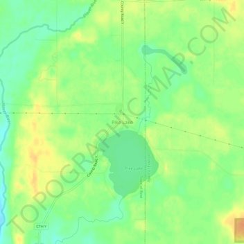
Name: Pike Lake topographic map, elevation, terrain.
Average elevation: 381 m
Minimum elevation: 364 m
Maximum elevation: 398 m
Make a donation
Other topographic maps
Click on a map to view its topography, its elevation and its terrain.
Wausau
United States > Wisconsin > Marathon County
According to the United States Census Bureau, the city has a total area of 20.33 square miles (52.7 km2), of which 19.22 square miles (49.8 km2) is land and 1.11 square miles (2.9 km2) is water. The city is located at an altitude of 1,195 feet (364 m). Wausau is close to the center of the northern half of the…
Average elevation: 394 m
Make a donation
Make a donation
Make a donation
Wausau
United States > Wisconsin > Marathon County
According to the United States Census Bureau, the city has a total area of 20.33 square miles (52.7 km2), of which 19.22 square miles (49.8 km2) is land and 1.11 square miles (2.9 km2) is water. The city is located at an altitude of 1,195 feet (364 m). Wausau is close to the center of the northern half of the…
Average elevation: 394 m
Make a donation
Bypass Channel Wisconsin River
United States > Wisconsin > Marathon County > Wausau
Average elevation: 371 m