
Make a donation
Montana-Village topographic map
Click on the map to display elevation.
Make a donation
About this map
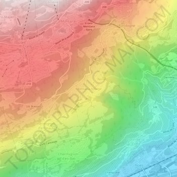
Name: Montana-Village topographic map, elevation, terrain.
Average elevation: 1,125 m
Minimum elevation: 512 m
Maximum elevation: 1,709 m
Make a donation
Other topographic maps
Click on a map to view its topography, its elevation and its terrain.
Mollens (VS)
Switzerland > Wallis > Sierre > Crans-Montana
The former municipality is located in the Sierre district, on the right bank of the Rhone river. The municipality stretches from an elevation of 900 to 3,177 m (2,953 to 10,423 ft). It consists of the villages of Mollens and Cordona, the scattered settlements of Conzor, Laques and Saint-Maurice-de-Laques as…
Average elevation: 1,996 m
Randogne
Switzerland > Wallis > Sierre > Crans-Montana
The former municipality is located in the Sierre district, on the northern slope of the Rhone valley. The municipality goes from the Rhone valley at an elevation of 540 m (1,770 ft) to Mont Bonvin at 2,995 m (9,826 ft). It consists of the village of Randogne (which was rebuilt in stone after the destructive…
Average elevation: 1,614 m
Montana
Switzerland > Wallis > Sierre > Crans-Montana
The former municipality is located in the Sierre district, above the right bank of the Rhone. It consists of the villages of Montana and Corin, part of the Champzabé, the hamlet of Diogne as well as the resort of Montana-Vermala (located at an elevation of 1,500 m (4,900 ft) and shared between Montana and…
Average elevation: 1,231 m