
Make a donation
Plitra topographic map
Click on the map to display elevation.
Make a donation
About this map
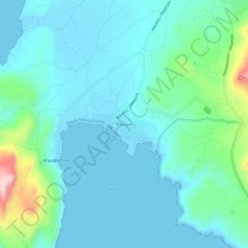
Name: Plitra topographic map, elevation, terrain.
Average elevation: 52 m
Minimum elevation: -2 m
Maximum elevation: 308 m
Make a donation
Other topographic maps
Click on a map to view its topography, its elevation and its terrain.
Municipal Unit of Sparta
Greece > Peloponnese, Western Greece and the Ionian > Laconia Regional Unit
Average elevation: 450 m
Municipality of Monemvasia
Greece > Peloponnese, Western Greece and the Ionian > Laconia Regional Unit
Average elevation: 131 m
East Mani Municipal Unit
Greece > Peloponnese, Western Greece and the Ionian > Laconia Regional Unit
Average elevation: 93 m
Municipal Unit of Sparta
Greece > Peloponnese, Western Greece and the Ionian > Laconia Regional Unit
Average elevation: 450 m
Make a donation
Sparta
Greece > Peloponnese, Western Greece and the Ionian > Laconia Regional Unit
Average elevation: 199 m
Municipal Unit of Sparta
Greece > Peloponnese, Western Greece and the Ionian > Laconia Regional Unit
Average elevation: 450 m
Municipal Unit of Sparta
Greece > Peloponnese, Western Greece and the Ionian > Laconia Regional Unit
Average elevation: 450 m
Spartia
Greece > Peloponnese, Western Greece and the Ionian > Laconia Regional Unit
Average elevation: 833 m
Make a donation
Laconia Regional Unit
Greece > Peloponnese, Western Greece and the Ionian > Laconia Regional Unit
Average elevation: 199 m
Municipality of Sparta
Greece > Peloponnese, Western Greece and the Ionian > Laconia Regional Unit
Average elevation: 699 m