
Thank you for supporting this site ❤️
Make a donation
Make a donation
Río Seco topographic map
Click on the map to display elevation.
Thank you for supporting this site ❤️
Make a donation
Make a donation
About this map
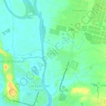
Name: Río Seco topographic map, elevation, terrain.
Location: Río Seco, Castilla, Piura, 20002, Perú (-5.15863 -80.63381 -5.11863 -80.59381)
Average elevation: 40 m
Minimum elevation: 30 m
Maximum elevation: 61 m
Thank you for supporting this site ❤️
Make a donation
Make a donation
Other topographic maps
Click on a map to view its topography, its elevation and its terrain.