Ketchikan topographic map
Interactive map
Click on the map to display elevation.
About this map
![Ketchikan topographic map, elevation, terrain](/pub/maps/relation/2jtj/cw5t3l/thumbnail.jpg)
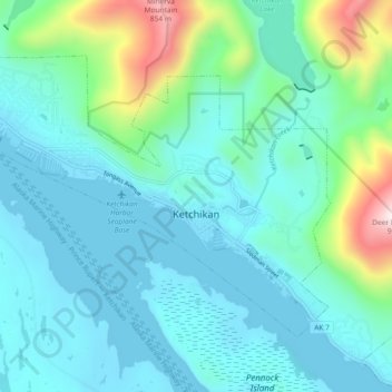
Name: Ketchikan topographic map, elevation, terrain.
Location: Ketchikan, Ketchikan Gateway, Alaska, 99901, United States (55.32653 -131.70734 55.36437 -131.61494)
Average elevation: 149 m
Minimum elevation: -2 m
Maximum elevation: 848 m
Due to its steep and forested terrain, Ketchikan is long and narrow with much of the built-up area being located along, or no more than a few city blocks from, the waterfront. Elevations of inhabited areas range from just above sea level to about 300 feet (91 m). Deer Mountain, a 3,001-foot (915 m) peak, rises immediately east of the city's downtown area.
Other topographic maps
Click on a map to view its topography, its elevation and its terrain.
![Juno Mountain topographic map, elevation, terrain](/pub/maps/node/sgp/htqn9w57/icon.jpg)
Juno Mountain
United States > Alaska > Ketchikan Gateway
Juno Mountain, Ketchikan Gateway, Alaska, 99901, United States
Average elevation: 438 m
![Mud Bay topographic map, elevation, terrain](/pub/maps/node/65z4/msscg51/icon.jpg)
Mud Bay
United States > Alaska > Ketchikan Gateway
Mud Bay, Ketchikan Gateway, Alaska, 99928, United States
Average elevation: 115 m
![Marten River topographic map, elevation, terrain](/pub/maps/way/cktj/8xl9419m/icon.jpg)
Marten River
United States > Alaska > Ketchikan Gateway
Marten River, Ketchikan Gateway, Alaska, United States
Average elevation: 207 m
![Whitman Lake topographic map, elevation, terrain](/pub/maps/way/2g3q/cm1hwncz/icon.jpg)
Whitman Lake
United States > Alaska > Ketchikan Gateway
Whitman Lake, Ketchikan Gateway, Alaska, United States
Average elevation: 313 m
![Herring Cove topographic map, elevation, terrain](/pub/maps/node/9vs8/xbb38kl/icon.jpg)
Herring Cove
United States > Alaska > Ketchikan Gateway
Herring Cove, Ketchikan Gateway, Alaska, United States
Average elevation: 157 m