
Make a donation
Sentinel Dome topographic map
Click on the map to display elevation.
Make a donation
About this map
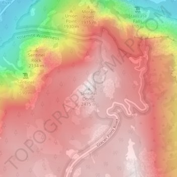
Name: Sentinel Dome topographic map, elevation, terrain.
Average elevation: 2,084 m
Minimum elevation: 1,207 m
Maximum elevation: 2,479 m
Make a donation
Other topographic maps
Click on a map to view its topography, its elevation and its terrain.
Yosemite Valley
United States > California > Mariposa County > Yosemite Village
Average elevation: 2,016 m
Echo Valley
United States > California > Mariposa County
Echo Valley is a valley in Yosemite National Park, at an elevation of 7,021 feet (2,140 m). It is located along Echo Creek, about 3 miles (5 km) west of Merced Lake, at 37°44′38″N 119°26′03″W / 37.7438°N 119.4343°W / 37.7438; -119.4343. It is bounded on the south by the Merced River.
Average elevation: 2,333 m
Make a donation
Yosemite Valley
United States > California > Mariposa County > Yosemite Village
Average elevation: 2,012 m
Yosemite Valley
United States > California > Mariposa County > Yosemite Village
Average elevation: 2,016 m