
Make a donation
Samos topographic map
Click on the map to display elevation.
Make a donation
Samos
Samos is near the eastern mountains of Galicia (the mountains of Lóuzara, Serra do Oribio and Mountains of Albola). The mean altitude is over 700 m and the highest elevation is the mountain of O Oribio at 1,443 m. The Sarria River, a tributary of the Miño River, collects water from the western slopes of the mountains; the Lóuzara River drains the eastern slopes, flowing to the Lor River and then to the Sil River. There are three well-differentiated areas: the central one, where the population is mainly located; the north area, more open and with smooth slopes, and Lóuzara, the southern area, with mountains and valleys.
Make a donation
About this map
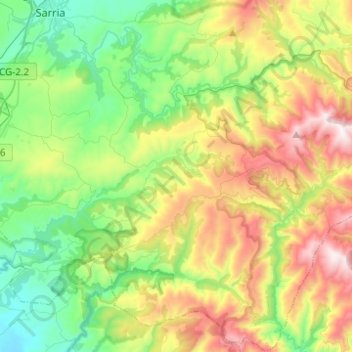
Name: Samos topographic map, elevation, terrain.
Location: Samos, Sarria, Lugo, Galicia, Spain (42.60339 -7.39270 42.78474 -7.17129)
Average elevation: 742 m
Minimum elevation: 350 m
Maximum elevation: 1,460 m
Make a donation
Other topographic maps
Click on a map to view its topography, its elevation and its terrain.