
Make a donation
Piracicaba topographic map
Click on the map to display elevation.
Make a donation
Piracicaba
The terrain of Piracicaba is predominantly rugged, with a notable depression in the central part of its territory. This depression extends along the east-west course of the Piracicaba River, becoming more pronounced within the urban area at the river's waterfall. This region separates the watersheds of the Piracicaba and Tietê rivers. Valleys converging toward the Tietê River in the southwest and the Piracicaba River in the central region trend north-northwest, creating more pronounced depressions in these areas. The lowest elevations are approximately 420 meters, while the highest average around 780 meters. The average altitude of Piracicaba is 528 meters, situated in a significantly sloped area with an average slope of 7.8%.
Make a donation
About this map
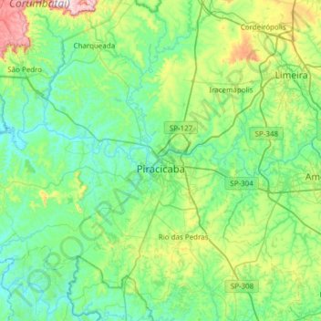
Name: Piracicaba topographic map, elevation, terrain.
Average elevation: 570 m
Minimum elevation: 450 m
Maximum elevation: 1,062 m
Make a donation
Other topographic maps
Click on a map to view its topography, its elevation and its terrain.
Kobayat Líbano
Brazil > São Paulo > Região Metropolitana de Piracicaba > Piracicaba
Average elevation: 521 m
Nova Piracicaba
Brazil > São Paulo > Região Metropolitana de Piracicaba > Piracicaba
Average elevation: 493 m
Mirante Rio Piracicaba
Brazil > São Paulo > Região Metropolitana de Piracicaba > Piracicaba
Average elevation: 505 m