
Thank you for supporting this site ❤️
Make a donation
Make a donation
Töss topographic map
Click on the map to display elevation.
Thank you for supporting this site ❤️
Make a donation
Make a donation
About this map
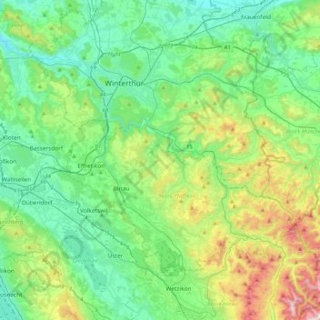
Name: Töss topographic map, elevation, terrain.
Location: Töss, Bezirk Winterthur, Zurich, Suisse (47.31229 8.55385 47.55328 8.96039)
Average elevation: 582 m
Minimum elevation: 353 m
Maximum elevation: 1,277 m
Thank you for supporting this site ❤️
Make a donation
Make a donation
Other topographic maps
Click on a map to view its topography, its elevation and its terrain.