
Thank you for supporting this site ❤️
Make a donation
Make a donation
Hayes Township topographic map
Click on the map to display elevation.
Thank you for supporting this site ❤️
Make a donation
Make a donation
About this map
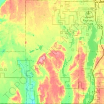
Name: Hayes Township topographic map, elevation, terrain.
Location: Hayes Township, Otsego County, Michigan, United States (44.85803 -84.84967 45.02963 -84.72572)
Average elevation: 407 m
Minimum elevation: 357 m
Maximum elevation: 470 m
Thank you for supporting this site ❤️
Make a donation
Make a donation
Other topographic maps
Click on a map to view its topography, its elevation and its terrain.